Heavenly Jerusalem Diagram
The celestial diagram is a model of an ideal society organized into 12 tribes, parts, and arranging its habitat and surroundings accordingly. The model was proposed by John Michell of England, relying on ancient sources [1]. He based his theories largely on the vision of John, on Plato, and also on a thinker from the late 19th and early 20th centuries named Charles Fort, who specialized in paranormal phenomena.
As I understand it, King David and the Jewish kings who followed him, especially Hezekiah, attempted to build Jerusalem and its surroundings according to the pattern of the celestial diagram, which was applied during the wandering of the tribes in the desert in the arrangement of the camp. When the celestial diagram in Jerusalem was constructed, it may have been aided by remnants of a similar attempt to apply the diagram to the land in the 18th century BCE (see the chapter on Canaanite Spirituality).
In Plato’s book Laws, the structure of the celestial city appears within the framework of the canon (laws) of harmonies in the land of Egypt—a canon that preserved the country and society unchanged for thousands of years, and in which the ideal astrological city appears divided into 12 tribes. In the book Republic, Plato refers to the celestial pattern and claims that those who understand it can uphold it in their hearts. Those who understand it enrich themselves and their surroundings, and those who do not understand it can see in the laws a reason to believe in God and to understand that things are working out much better than they seem.

Throughout the world, over the generations and right up to the 19th century, organizations of societies consisting of 12 tribes centered around a temple or some other center, led by a holy king associated with this center, have appeared. This is an archetype that passes between cultures or is reached independently. Along with it is a code of numbers and proportions, which constitutes the essential, comprehensive, and organized pattern of the ideal emerging reality. An attempt to implement such a celestial pattern was made during the wanderings of Israel in the wilderness, by arranging 12 tribal camps, divided into 4 groups according to the cardinal directions, around the tabernacle and the tent of meeting in the center.
The cosmological model is based on a synthesis of the laws of numbers 1 to 12, expressed in the simplest geometric form by a circle, which is the symbol of perfection. The radius of this circle is 5040, a multiplication of the numbers 1, 2, 3, 4, 5, 6, 7, and the circumference of a quarter of a circle of this radius, between the equator and the zenith, is 7920, a multiplication of the numbers 8, 9, 10, 11. The measure used in various ideal societies was related to the human body or the world, and since the measure used in the Temple was the cubit, it is likely that in the sacred urban planning of Jerusalem the dimensions of the sacred layout were 5040 cubits.
On the circle whose radius is 5040 cubits, a square with a side of 7920 cubits is placed, so that the square is mostly inside the circle but the corners of the square protrude slightly beyond it. The distance between the side of the square on the equator and the circumference of the circle outside it is equal in this case to 1080 cubits, which is the radius of a circle centered on the circumference of the circle, half of it inside the circle and half outside it.
Twelve circles with a radius of 1080 cubits can be placed between the corners of the square that protrude beyond the circle, three between each protrusion in each direction, so that they form a circle of twelve circles in the circumference of the circle. In the center of the large circle, a small circle with the same radius, 1080 cubits, is placed, and thus we have an array of 12 small circles arranged in a circle, around a central circle of the same diameter. Between them there are breaks that are the corners of the square. According to John Michell, this is the celestial diagram that serves as the basis for the design of the Stonehenge stone circle, and also of the Lady Chapel in Glastonbury, England, which was built in the Middle Ages by Eleanor of Aquitaine (we will expand of her connection to Jerusalem later).
According to John Michell, the square is the geometric symbol of matter, human reason, and the man-made environment, in contrast to the celestial and infinite circle that is the circumscribed circle. Within the square, an inner circle can be created that rests on the square (its diameter is the side of the square) and represents the ideal Earth. In this case, the diameter of the inner circle would be 7920, which is the distance in miles of the Earth’s diameter at the equator. Hence, the use of the mile originates from ancient sacred measurements relating to the dimensions of the Earth. The diameter of the small circles in the diagram is 2160 (twice the radius of 1080), which is the diameter of the Moon in miles, and also the number of years of an astrological era.
The diagram represents the celestial city. In the center of the inner circle is a point that is the castle and the ruler; the circle itself is the city; the area of the large circle is the area of the inhabited areas associated with the city. Within the circumference of the large circle is the area that the city needs for agricultural needs. Around the large circle (its circumference is 31,680 cubits), there are hills with temples surrounding the inhabited area. In addition, the diagram is the overall image of creation, within which are the calendar, months, and years of the great astrological year. The 12 outer circles indicate the 12 astrological signs, 12 types of people, 12 gods, 12 tribes, 12 stelae or holy places around the central holy place, and so on.
The diagram inspires a desire to shape society in its own image, and this is done by the first holy law-giving king. He is the equivalent of Plato’s philosopher king. This can appear through an individual or a group (association). One of the symbols of this ruler is the Holy Grail, and the symbol of the diagram is the Round Table. Since it is about numbers, any thinking mind can come to the discovery of this diagram on the basis of its special numerical properties, and this brings about an energy of revelation that allows for a reordering of human affairs. Thus, God first reveals this secret to the enlightened ones, who become the first legislators and kings.
The philosopher-ruler establishes and shapes a country according to a divine pattern. He brings about balanced and focused thought, cultural and spiritual renewal. Revelation brings the right person at the right time to renew the world, and then a cosmologically organized nation is created. The features of revelation are similar, because they are archetypal and based primarily on numbers (and also forms arising from them). Number is the first paradigm, the pure and abstract form of divine thought and logic, which determines our relationship with all things. Number is the ideal expression of the ideal universe, and so we also find in Kabbalah the Sefirot as the key to understanding the world.
Following the revelation, the nation begins to be built from the center into four directions—quarters—and from there into 12 tribes, with each of the 12 gods or astrological signs ruling a tribe. In addition, a cycle of festivals is created over the months of the year, in which everyone participates, including a pilgrimage to the national center every year. Such an arrangement appears in Scandinavian mythology and in the organization of Iceland, the Faroe Islands, and also in the Celtic organization of Ireland. It appears in the organization of the Croatian tribes, and even in Madagascar in the 19th century, around the center of the Hova tribe and its capital Antananarivo.
In the Israeli case, this is the arrangement of the 12 tribes of Israel around the Tent of Meeting and the Tabernacle during the wandering in the desert. The meaning of leaving Egypt was the building of a new society, a new people. God commands the Israelites to establish a camp based on the division into 12 tribes, with the Tent of Meeting, the Tabernacle, and according to some versions also the Well of Miriam in the center.
Around the inner perimeter are four priestly camps located according to the cardinal directions: on the east side is the camp of Moses, Aaron, and Miriam. On the west side is the camp of the sons of Gershon, on the south is the camp of the sons of Kohath, and on the north is the camp of the sons of Merari. On the outer perimeter are three tribes in each direction, one of which is central. On the east side is the camp of Judah, together with Issachar and Zebulun; on the west is the camp of Ephraim, together with Manasseh and Benjamin; on the south is the camp of Reuben, together with Simeon and Gad; and on the north is the camp of Dan, together with Asher and Naphtali.
The number four symbolizes completeness and is also related to our spatial perception (looking forward, we divide the world into four directions), to four types of appearances in the world—both aggregate states (solid, liquid, gas, and energy) and elements (earth, air, water, and fire). The number three is related to dynamism, processes, especially thought, and our perception of time.
And so, four appearances of three give the number 12. This is a number that symbolizes the diversity of human appearance, and therefore different brotherhoods, whether of gods or of humans, had 12 participants. And so, we have 12 Olympian gods on the one hand, and 12 tribes of Israel on the other. And if we want to create a new ideal society in which there is representation of all types of humans, then the pattern that is desirable to use is a pattern of 12.
When the tribes settled the Land of Israel, the square structure of Ephraim, Dan, Reuben, and Judah was preserved around the Jerusalem area and the tribe of Benjamin in the center. Although not in the original directions, the duality was also preserved: Reuben in the east versus Dan in the west (instead of Reuben in the south and Dan in the north), Judah in the south, and Ephraim in the north (instead of Judah in the east and Ephraim in the west).
If we look for a place where there is proximity to the most of the 12 tribes, it is in the Jerusalem area, which is close (clockwise) to Judah, Dan, Ephraim, Benjamin, Manasseh, Gad, and Reuben. The tribes from which Jerusalem is relatively distant are Simeon, Zebulun, Issachar, Naphtali, and Asher. In other words, if the Tabernacle was in the heart of the tribes of Israel, then the location of the Temple in Jerusalem is also relatively in the heart of the tribes of Israel. There is no better central location than this according to the map of the tribes, a location that also preserves the square division into four main tribes according to the cardinal directions.

Diagram of Jerusalem
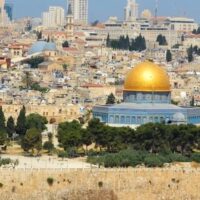
If we look at the topographic structure of Jerusalem, we will find that Mount Moriah is located in a valley surrounded by a circle of mountains. David and Solomon built the center, and the question is whether other buildings were also built around the perimeter of the valley that relate to this center, as was the case in other holy cities in ancient times.
The best example and closest to the case of Jerusalem is the establishment of the new capital city, Akhetaten (Tel el-Amarna), by Akhenaten in the 14th century BC. Akhenaten chose the location of the capital because of its unique physical shape and celestial orientation. As we mentioned earlier, he built a temple to the rising sun god Aten in the center of the city. But in addition to this, he also sanctified the perimeter of the surrounding cliffs and established stelaes at regular intervals around the city—a kind of energetic boundary of holiness [2].
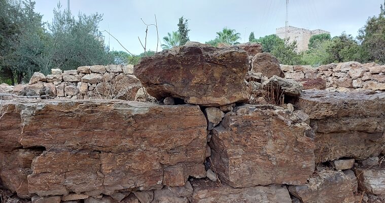
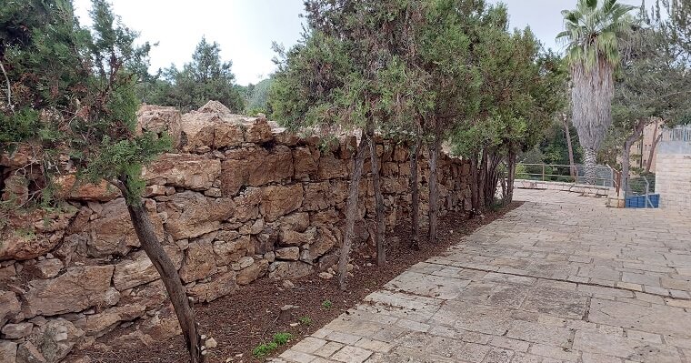
The highest peak within the circle of mountains surrounding Jerusalem is the French Hill, located 2.7 km north of the Dome of the Rock—a measurement equal to 5040 Egyptian royal cubits (7 palms), which is the radius of the celestial diagram as we saw in the previous chapter. At this place there are two large modern concrete water reservoirs, and next to them stands a large, unique ancient building from the time of the First Temple, 18 meters long and more than 13 meters wide.
The building consists of an open courtyard surrounded by rooms (in the style of an Israelite house). Its walls are thick, and the inscription at the site says that it is a bastion from the First Temple period that was probably intended to protect the mountain road north of Jerusalem. However, the building is made of huge flint stones that are not found in the area, unlike the limestone used in the other buildings and fortifications of Jerusalem, and this raises many questions: Why was the bastion built of flint stones? And where did they get them?
Flint has been considered a sacred stone since prehistoric times, because it was used to light fire and to make tools. Thus, areas of fine flint, such as Mount Karkom in the Negev, became sacred places visited by pilgrims. Flint was identified with the sacred fire that burned in caves, houses, and temples. In addition, flint was used for magical and spiritual protection, and sometimes in jewelry and construction. In biblical times, flint knives were used for circumcision, and the stone was seen as a symbol of power, as appears in Isaiah 54:12: “I will make your pinnacles of agate, your gates of carbuncles, and all your wall of precious stones.” Carbuncles is flint, and it is possible that its ideal location at the gates led to the use of flint in this building, which was seen as a gateway to the holy city. According to the celestial diagram, the building is on the border of the sacred circle surrounding Jerusalem, and therefore, from a magical-religious perspective, it implements the verse in Isaiah.
The walls of the impressive structure, located directly north of Mount Moriah, are made of huge, special, and powerful flint stones, which provokes further thoughts and speculations about the role of the “Bastion.” One of the keys to understanding the role of a structure is its location, and indeed the “Bastion” is located in a special place—exactly where Jerusalem is first revealed to those arriving along the mountain path from the north. This had significance in ancient times.
An American researcher named Chester Charlton McCown, who worked in Jerusalem during the Mandate period and researched Muslim holy sites, discovered that in Muslim holy tradition [3], a wave of stones is piled up at the place where the holy site is first seen. The waves are also called arches, and when they were erected, people would sing a nasib (religious song). This is probably a much older tradition, so there is importance to the place from which the holy site is first seen—and such is the location of the “Bastion” on the French Hill.
In addition, the fortress is on top of a mountain that is part of a mountain circle around the holy site—Mount Moriah. As mentioned earlier, if we consider the mountain circle as a kind of ancient stone circle, then in each stone circle there is one stone that is different from the rest and opens it energetically. For example, in the Boscawen-Un stone circle at the edge of the earth in Cornwall, there are 19 stones, all of them made of granite except for one that is made of light quartz, located at the place of sunset on 1.11, the Day of the Dead. This stone opens the circle energetically, and ceremonies were likely performed there on that day. Another example is Tel Gezer, where there are ten standing stones—all local except for one stone (the seventh), which was brought from Jerusalem and is harder than the others. This stone connects the place to Jerusalem, as I showed in the chapter on energy lines.
The north was considered sacred in ancient times; it was the place of the fixed stars that symbolized eternity—the dwelling place of the gods. In the Psalms it is written: “Beautiful in its loftiness, the joy of the whole earth, like the heights of Zaphon (north) is Mount Zion, the city of the Great King.” (Ps. 48:2). If there was an arrangement of buildings/sites around Jerusalem connected to some type of sacred diagram, as existed in other holy cities, then the north has a special significance within this arrangement, and it is appropriate that the structure built there be constructed of different materials that would energetically open the circle. I am not claiming that the “Bastion” was not used for defensive purposes or tax collection, but that in addition to this it also had a magical-spiritual importance. In ancient times, physical and magical protection were linked.
In the case of Jerusalem, the north is also the location of the priestly city of Nob, where the Tabernacle was located after the destruction of Shiloh. Indeed, the structure on the French Hill is located on the line connecting Jerusalem with Shiloh. It itself is oriented on an east-west axis, with a slight tilt to the southeast—that is, toward the sunrise on the longest day of the year. This orientation is important in the sacred topography of Jerusalem and is related to the sunrise from the southern shoulder of the Mount of Olives on the longest day of the year, as seen from Mount Moriah (more on this later). Even if there was no magical intention in the construction of the building, it is possible that synchronicity caused it to be built where it was built and precisely with flint stones. In any case, it is likely that it was built on the foundation of an earlier site. It is true that flint stone is hard and good for defense, but this is not its only property, and for the purpose of the “Bastion,” ordinary stones could have sufficed.
The flint structure on French Hill is 5040 Egyptian royal cubits from Mount Moriah, which fits the dimensions of the celestial diagram. The next step is to see what is located at the same distance south of Mount Moriah. Indeed, exactly 5040 cubits south of the Foundation Rock is the Armon HaNatziv Ridge (Governor’s Palace), a prominent mountain that juts out south of Jerusalem. Thus, the Temple was built halfway between the Armon HaNatziv Ridge and the summit of French Hill, the two highest and most prominent peaks to the north and south of Mount Moriah.
Then the question arises: what is located 5040 cubits west of Mount Moriah? Surprisingly, what is located there, in a precise location, is the Israeli parliament (Knesset) building. It is as if a divine planning hand came and located the source of power of the State of Israel precisely there, in such a way that it could receive its energy from the sacred center of the city. It is likely that the site’s planners were unaware of the celestial diagram, and it must be assumed that synchronicity was at work here. John Michell argued that the sacred diagram operates through the subconscious of the planners of cities and sacred places, and this may be the case here as well.
In my doctoral thesis on holy places in Israel [4], I discovered to my surprise that the area of the new Western Wall plaza, built after the Six-Day War, is surprisingly and precisely the same size as the dimensions of the Ezra (courtyard) in the Temple. The importance of the Ezra was great because it housed the Divine Presence, and the sacred space included it and not just the building. The dimensions of Ezra are given at Mount Sinai together with the dimensions of the Tabernacle; they are precise and meaningful. The construction of the new Western Wall plaza with these dimensions, even if not intentional, gives the place energetic power, according to the magical principle of “like attracts like.” Even if one does not believe in it, the coincidence is fascinating and thought-provoking.
The synchronicity is not only in the distance of the Knesset from the Temple Mount (and so are all the buildings adjacent to it: the Israel Museum, the government ministries, the new National Library), but also in its orientation to the Temple Mount. The Knesset is located on a precise east-west axis from the Temple Mount—a main energetic line of Jerusalem that appears in alternative theories and is called the “Messianic Line” [5]. This line connects all the most sacred places in the city: the Mount of Olives, the Temple Mount (the site of the Temple), the Church of the Holy Sepulchre, and now the Knesset. Even the best city planner could not have chosen a better location energetically—especially considering that the location of the previous governmental seat during the British era (the Governor’s Palace in Armon HaNaziv) was the same distance from the Mount Moriah (5040 cubits), at a 90-degree angle to the Orientation line of the Knesset, heading south instead of west.
The next question is: what is located 5040 royal Egyptian cubits east of Mount Moriah? Currently there is nothing there except Palestinian neighborhoods of the eastern part of the city, between the Mount of Olives and Ma’ale Adumim. In the past, this may have been the location of the settlement of Bachurim, to which David fled after Absalom’s rebellion. However, if the day comes and the long-awaited peace arrives and the Palestinians want to establish a parliament for themselves—a seat of government of their own—my recommendation would be to establish it in this location, thereby completing the sacred layout of Jerusalem in a way that ensures balance and harmony between all the parts.
The celestial diagram was probably the basis for the location of ancient sites and the construction of monuments in a circle surrounding Jerusalem—a plan that was followed in the days of David and Solomon, and completed by the kings who followed them. Currently, only one site out of the 12 sites has been found, but I am sure that more sites will be discovered in the future. It is worth noting in this context that the length of the Temple Mount plaza during the time of Herod was approximately 1080 cubits, a number that corresponds to the inner circle in the diagram’s pattern.
Finally, it is worth adding in this context that the sacred architectural tradition of Egypt and other ancient cultures saw in the holy cities a reflection of the sky [6]. Usually, places like Rome, Thebes (the capital of Egypt), Babylon, and other such cities had a master plan that was maintained and advanced by a school of sacred architecture that existed in the temple complexes. It is possible that this was also the case in Jerusalem, and that the master plan was maintained by the priests in the Temple, some of whom were associated with prophetic circles (as we will see later).
Footnotes
[1] Michell, J. (2008). The dimensions of paradise: Sacred geometry, ancient science, and the heavenly order on earth. Simon and Schuster.
[2] Stevens, A. (2016). Tell el-Amarna. UCLA Encyclopedia of Egyptology, 1(1).1
[3] McCown, C. C. (1921). Muslim shrines in Palestine. The Annual of the American School of Oriental Research in Jerusalem, 2, 47-79.
[4] Ben Arie, Z. (2023). Generators of Sacredness in Charismatic Sacred Places in Israel (Doctoral dissertation). University of Haifa, Faculty of Humanities, Department of Israel Studies, Haifa, Israel.
[5] Michell, J. (2000). The Temple at Jerusalem: A Revelation. Weiser Books.
[6] Anthony West, John. Serpent in the Sky: The High Wisdom of Ancient Egypt. Quest Books, 1993.