One of the world’s oldest spiritual traditions, dating back to our hunter-gatherer days, is that of sacred geography, and there is no place like Jerusalem to exemplify this. Jerusalem sits in a sort of topographic crater, and it has been said: “Jerusalem, mountains all around it.” The shape in which the ancient city is situated, a valley surrounded by a circle of peaks, is an arrangement reminiscent of other holy cities around the world such as Mexico City, Rome, and Kathmandu. The shape of the circle is archetypically associated with holiness, as expressed in ancient stone circles, mandalas, religious structures, and rituals around the world. Indeed, there is only one place topographically similar to Jerusalem in the central mountain range of the Land of Israel – Hebron, a holy place in its own right and the seat of King David before he moved to Jerusalem.
My argument is that the topographical shape of a crater, a sort of amphitheater, enables and reinforces the visitor’s experience of holiness in the city. This feature was noticed by the first city planners in the 1920s: Charles Robert Ashbee, Patrick Geddes, and Clifford Holliday. They determined (with the support of Governor Ronald Storrs) that the city’s planning would emphasize this circular structure, and that new public buildings, such as the University on Mount Scopus, the YMCA, the Commissioner’s Palace, the Scottish Church, and the like, would be built in a circle around the Old City, resting on the peaks of the surrounding mountains, looking out over the “Holy Basin.” The principles of urban planning were not only practical, but were also influenced by “spiritual” architectural concepts. Thus, a circle of towers, neighborhoods, and buildings was created, surrounding a valley within which lies the walled square of the Old City; this is the Holy Basin, highlighted and distinguished by a strip of gardens around it. In other words, the urban planning of Jerusalem creates a mandala – a combination of square and circle, which, according to Jungian psychology, symbolizes the self [1] but more on that later.
The circular structure of Jerusalem focuses man back on himself, on the inside, and from there he is left with two paths: up or down. Indeed, Jerusalem is a place of “up” or “down”: on the one hand, it is the place of connection to heaven, the navel of the world, the place to which angels descended and from which they ascended, the place from which Jesus and Muhammad ascended to heaven, the place where the Temple stood and where the great prophets worked. On the other hand, Jerusalem is a city of wars and bloodshed, the place where children were sacrificed to Moloch, and where lives are still sacrificed every day on the altar of blind hatred. In other words: Jerusalem is a place of hell and paradise. “Down” in this sense is connected to evil, and “up” to good. “Down” to matter and “up” to spirit. Our world is a world of duality, but the wisdom is to connect matter to spirit and thereby redeem it, and this is the meaning of the world axis that connects the planes and the times, Jerusalem being the navel of the world and therefore a classic world axis.
The unique shape of Jerusalem – mountains surrounding it – was created due to the capture of the Kidron River, which originally flowed westward (into the Sorek River channel), by the Syrian-African Rift, which led to the flow of water eastward and rapid erosion that created a kind of geological crater, similar to the craters in the Negev but with milder contours. The deep erosion exposed ancient rock layers in the Kidron River valley, and thus the rock and soil in the Old City area are different from those in the Judean Mountains (the foundation rock in the temple is a hard limestone from the Lower Cretaceous period). Another product of the rapid erosion was the appearance of a large spring in the Kidron valley – the Gihon Spring, which in turn made it possible to establish a small city next to it. In addition, Jerusalem is located at the lowest point in the mountain watershed, which allows water to be brought to it from the higher Bethlehem and Hebron mountains.
According to ancient traditions, the rock of the Temple Mount is the foundation rock from which the entire world was created, all other rocks are connected to it. Its visible part is only the tip of a huge “rock iceberg”, under which is the source of all the world’s springs. Underground rivers flow from the foundation rock to the four cardinal directions. Four rivers flow from the rock: the Gihon, Pishon, Tigris, and Euphrates. The Gihon and Pishon are considered the Blue Nile and the Tigray River in Ethiopia, and the Euphrates and Tigris flow into the Persian Gulf. Hence, Jerusalem is located at the geographical center point between Ethiopia and Iraq, in the center of the Fertile Crescent.
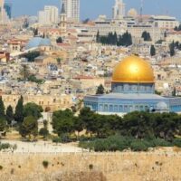
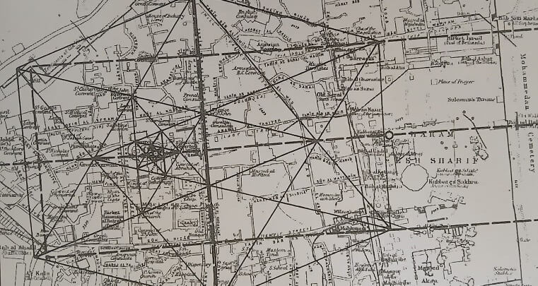
When we get down to the details of the sacred geography of Jerusalem, we discover amazing things: if we connect the mountain peaks surrounding the Old City with straight lines, four lines will be formed: the line connecting the summit of Mount Scopus and Abu Tur, the line connecting the summit of the Mount of Olives and Rehavia, the line connecting the Mount of Anointing and Romema, and the line connecting the Ammunition Hill and the Palace of the Governor. These four lines have one common meeting point, and it is exactly at the location of the Foundation Rock. Not only that, they form an octagonal star according to the cardinal directions, with equal sides. This octagon is exactly the octagon of the Dome of the Rock, so that the structure of the Dome of the Rock echoes the mountains around it and emphasizes the centrality of the Foundation Rock.
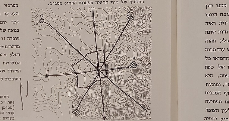
The location of the Dome of the Rock, therefore, is not accidental. The entire structure of the surrounding valley supports it, and therefore the entire valley is part of the Dome of the Rock temple. It is true that this is a natural arrangement, but synchronicity sometimes appears through natural arrangements. There are places around the world where shapes appear that seem to have been planned in advance and are appropriate for the activity that takes place there. If there is some kind of order in the world, or a world of hidden order that affects the world of appearances, then this should also be expressed in nature. For example, in Ethiopia there is a high table mountain with cliffs around it, like Masada but in the shape of a cross, and there is a piece of the true cross on it. Another example is that many of the holy sites of medieval Europe dedicated to the Archangel Michael are on a single line called the Archangel Michael Line. This brings us to the following feature:
The sacred geography of Jerusalem does not end at the Dome of the Rock. There is an enigmatic verse in the book of Ezekiel that describes the priests on the Temple Mount, their backs to the temple, and they are waiting for the sun to rise on the Mount of Olives (Ezekiel 8:16). Indeed, if we draw a line westward from the summit of the Mount of Olives, we find that it passes through the Gate of Mercy, to the Dome of the Winds on the Temple Mount, which according to one hypothesis is the location of the Holy of Holies of the Temple. This line is called the “Messianic Line,” because this is the line along which the Messiah will come. He will come from the Mount of Olives and enter the Temple Mount through the Gate of Mercy. It is interesting to note that if we continue this line, it reaches the Rock of Golgotha in the Church of the Holy Sepulchre, and the street layout of the Roman city of Aelia Capitolina, which is the basis of the street layout of the ancient city to this day, rests on this line and not by chance, as we will see later.
The synchronicity of Jerusalem’s geography does not just amount to a precise circle of peaks surrounding the Foundation Rock, It has another feature: the most prominent peak – Mount of Olives is located precisely east of the Temple Mount. Furthermore, Jerusalem has a kind of celestial diagram as we will see later.
Synchronicity appears not only in the earth’s geography, but at times relates to the celestial bodies as well, and the most prominent example of this is the equal size from our perspective of the circle of the moon and the sun, but we will expand on this later as well as on the connection of Jerusalem and the Land of Israel to these celestial bodies and the stars.
The sacred geography of Jerusalem is based on the east-west orientation of the messianic line, which is the axis of sunrise on the days of the equinoxes, in relation to the circle of the mountains around the Temple Mount. The sun’s ray which was perceived in ancient times as masculine, fertilized the circle that was perceived as feminine [2].

When a site for a capital city was chosen in ancient times, it needed to be a fitting place in terms of its terrain and location, but also a fitting place in its arrangement according to the principles of sacred geography and orientation toward the heavenly bodies, especially the sun and the northern stars. The place chosen had to combine these two conditions, since the capital city had to be a place of connection between heaven and earth. Thus, the first pattern of built sacred places is a stone circle such as Stonehenge in England and Rugum Hiri in the Golan Heights that is oriented toward the sunrise on a special day of the year. However, the artificial circle often refers to a natural circle of the surrounding landscape, as seen in the case of Rugum al-Hiri in the Golan Heights. Hence, natural circles, such as a crater, were also sacred in ancient times, especially those that had orientations towards the sunrise on special days of the year, and this, in my opinion, indicates that Jerusalem was a holy place, or at least one that was considered special, much before the establishment of the Temple.
In my humble opinion, this is one of the reasons why King David chose Jerusalem to be his capital, a place for the house of God. There were other good reasons of course, mainly political, but the choice must also be viewed from an esoteric perspective. King David, who was a shepherd in Bethlehem, certainly walked with his sheep in the valley of Jerusalem, and he probably noticed the uniqueness of the place in terms of its shape – a circle and the heavenly orientations, and this was engraved on him. Indeed, in this place he meets the angel of Jehovah at the threshing floor of Aruna the Jebusite, more on that later.
The claim that King David chose Jerusalem for its sacred geography is based on similar cases of establishing a new capital city. When the Egyptian king Akhenaten wanted to establish a new capital, he walked along the Nile until he found a place where there was a bend in the river that opened into a large, semi-circular valley – this is the first condition for establishing a holy city, the shape (geometry) of the land. The day was special and Akhenaten noticed that in the cliffs to the east there is an opening in the shape of the first Egyptian letter and through it the sun rises, this is the second condition for establishing a holy city. And indeed the city is called Akhenaten – the horizon of (the god) Aten [3]. The significance of establishing the city is the establishment of temples and the strengthening of the alliance between God and humans, and therefore the chosen site (and also the master plan of the city) must receive the approval of the god who is supposed to reside in it, and bestow his blessing on humans.
Reinforcement for this claim can be found in the world of images of Lurianic Kabbalah. According to the Haari’s teachings, when God wanted to create the world, he had to withdraw from it first, thus creating a circular empty space called “Tahiro”, into which the first ray of spiritual light penetrates, which forms itself in the shape of the spiritual man, and thus the process of creation begins. Thus, the circular valley of Jerusalem (the sacred basin) is the Tahiro, a ray of sunlight penetrating it from the direction of the Mount of Olives at sunrise is the first ray of spiritual light, and it takes on the garments of the temple, which is in the form of Adam, the spiritual man. This cosmic drama is renewed continuously through temple worship and its structure, as we will see later on.
The sacred geography of Jerusalem is expressed not only in the macro – in the general directions and the overall shape of the terrain – but also in the micro, that is, in the specific elements of Mount Moriah. At the top of the mountain is a large rock, below it is a cave, and at the foot of the mountain is a pulsating spring. These three elements are archetypes of holiness, which appear in many holy places around the world, and are classic characteristics of sites of deep spiritual significance.[4] Rocks appear in all cultures as a representation of divinity, and especially in the Land of Israel. Water symbolizes life, especially when it flows from rock. The existence of a relatively large, pulsating spring beneath Mount Moriah, topped by a large, prominent rock, connected this rock with the water flowing beneath it in the imagination of the ancients, and led to the development of legends about the Foundation Rock as the source of all the water in the world. The existence of a cave at the summit of the mountain is relatively rare, and recalls Moses’ stay in the rock crevice on Mount Sinai, while God passed by him.
Jerusalem was probably a sacred place even when we were hunter-gatherers, a place where prehistoric tribes used to come during their wanderings to feel the holiness and connect with the spirit world, thanks to its sacred geography, but geography is not only a relief, as my father (historical geography) taught me, but also a cover, what humans added to the landscape.
With the development of human civilizations, many elements of sacred architecture were also added to the natural sacred place, with the understanding that although it is perfect and an expression of divine truths, everything wants to grow and develop, just as all metals strive to become gold, so too the planet strives to become a perfect mirror of the heavenly paradise. Humans were created to be an aid in completing this goal, and thus nature, which is perfect, can be enriched by human efforts. This is done by building monuments, temples and holy cities. Humans are trying to create the New Jerusalem on earth, which is to some extent also an imitation of heaven. But more on that later.
Jerusalem in relation to the world
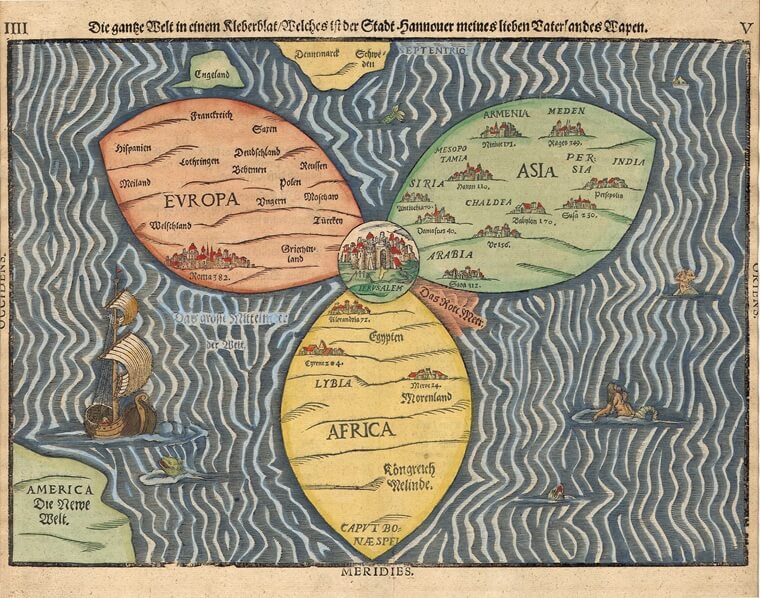
If we expand our scope and look at the location of Jerusalem in relation to its surroundings, to the Land of Israel and to the world, we will discover fascinating things. First of all, it turns out that the expression “Jerusalem is the navel of the world” is correct. If we connect all the continents together, attach South America to Africa, North America to Europe, and Australia to Asia, and try to calculate where the center of the recreated supercontinent will be, we will find that it is more or less in Jerusalem. Geodetically (measurements of the land), Jerusalem is located at the center of the land mass of the earth. At the heart of a country that is a meeting point between three continents (Africa, Asia and Europe) and two seas (the Mediterranean and the Red Sea). We will return to this topic later.
If we consider the Earth as a living organism (Gaia theory), then the streams and rivers on the surface of the land are the blood system of the planet, and constitute channels of energy. This explains from another perspective the tradition concerning the Foundation Rock as being the source of all rivers and waters in the world.
And here we discover another interesting thing: the streams surrounding the city of Jerusalem are part of the drainage basin of the Kidron Valley that flows into the Dead Sea. In other words, in terms of water, Jerusalem is connected to the Dead Sea. The Kidron Valley is the deepest and most vigorous of the Judean Desert canyons, and it managed to cut through and cross the watershed of the mountain to the east, emerging from a kind of crater basin in an area that was originally supposed to drain to the west.
Jerusalem’s is connected geologically to the East, this is expressed in the fact that its eastern part, which is the Mount of Olives and Mount Scopus, has a rock similar to that of the Judean Desert (Sanun). If you climb the most prominent mountain in the circle of mountains of Jerusalem, namely the Mount of Olives, you see the Judean desert as if on the palm of your hand on the east, it begins at the eastern foot of the mountain (Ma’ale Adumim) and reaches the Dead Sea. In other words, Jerusalem is located on the border between the desert and the fertile land. Indeed, throughout the periods, as we will see later, there was a spiritual connection between Jerusalem and what is called “the desert of the holy city”, between the religious center in Jerusalem and spiritual groups who chose to live in the Judean Desert, such as the Essenes or the Christian monks, and it should be remembered in this context that the Kidron Valley reaches the Dead Sea in the Qumran area.
The rivers are the blood system of the Earth, but the mountains and valleys are the bones and flesh of that organism. These are not just theoretical thoughts, but a point of reference that stems from the understanding that the universe is alive and evolving, and so is every part of it. Chemist James Lovelock and microbiologist Lynn Margulis proposed the Gaia hypothesis [5], which claims that the Earth regulates and adapts itself to the changing environment by encouraging various forms of life, what can be deduced from this is that the Earth is an intelligent, living entity, only that its way of operating and its times are different from ours.
If the Earth is indeed a living organism, then it is reasonable to assume that different parts of it have different functions, similar to other living organisms, and that it has various organic systems, and thus the physical structure of the globe is not accidental. For example, if we look at the mountain ranges of the Earth, we see that they are generally in the shape of the English letter H, with the Andes and Rockies forming one vertical line, the Caucasus and Himalayas forming the horizontal middle line, and the mountains bordering the Pacific Ocean (New Zealand, Philippines, Vietnam, Japan, etc) forming the other vertical line of the H.
Particularly unusual is the mountain range of the Rockies and Andes, which begins in Alaska near the North Pole and reaches continuously to Patagonia near the South Pole, it can be compared to the spine. And something else should be added in this context, even if scientifically the perception of the Earth as an organism is not correct, then from the point of view of the human societies, which tends to humanize the environment, the world is perceived as such.
Within this framework, the Syrian-African Rift has a special place. This is the longest valley in the world, stretching from Mozambique to Turkey, more than 6000 km long, a measure that is interestingly and synchronously equal to the radius of the Earth at the equator. The Syrian-African Rift is the only valley visible from space on the surface of the Earth, it is geologically active, and there is a lot of animal activity along it, it serves as a main migratory route for birds from Europe to Africa, and also a route for the great migration of herds (zebra and antelope) from Mozambique to Kenya.
In relation to human beings, most of the different types of humans, including Homo sapiens, appeared first in places that are inside or in proximity to the Syrian-African Rift valley (in Ethiopia for example), and many of the ancient cultures and religious manifestations, such as Egypt and the Land of Israel, appeared next to it.
For all these reasons, the Syrian-African Rift can perhaps be compared to a kind of womb of the Earth, giving and supporting life, and in this context, the various parts of it are important, with no doubt that one of the most special parts is the Dead Sea, which is also the lowest land place in the world (400 meters below sea level), a fact that probably has an esoteric meaning.
The high concentration of salt crystals in the Dead Sea is an anchor for energies, and despite the name of the lake – the Dead Sea, from an energetic point of view it is very alive. There are not many lakes in the world like the Dead Sea, the concentration of salts in the Dead Sea is close to 35%. Apart from Lake Van in Turkey and Lake Assal in Djibouti, there are almost no bodies of water in the world with such a high concentration of salt, and in addition, it is different from the two lakes mentioned in that it is acidic and not alkaline, as a result of the influence of the geology of the Syrian-African Rift. The Dead Sea is also very deep for a body of water of its size (nearly 400 meters).
Salt is one of the most mysterious elements on Earth, and the mystery is heightened by the fact that the seas manage to maintain a constant salt concentration of 3.5% even though rivers bring more and more salt to them over time, similar to human body fluids such as blood, which also maintain a constant salt concentration (usually 0.9%). It is as if salt has a certain energetic function precisely in the concentration in which it is found. Salt is an essential component of the human body, a deficiency in it can lead to medical problems, and in addition it had an important role in ancient times as a food preservative (before the invention of the refrigerator), which is why it is called white gold. However, salt also had a role in religious rituals, mainly of purification and protection, and this suggests its energetic properties.
If the Earth is an organism, then the existence of this special body of water in the continental center of the Earth at the lowest point in the world, as part of the Syrian-African Rift, certainly has significance. And as we noted earlier, the drainage system of the Kidron Valley, geology, and distance (geography) tie Jerusalem to it. The Dead Sea is a day’s walk from Jerusalem, and can be seen from many parts of Jerusalem. If we continue the attribution of parts of the Earth to the human body, then the Dead Sea is the navel of the Earth by virtue of being the lowest place in the world, and at the heart of the continental body, and this reinforces the notion that Jerusalem, which is connected to the Dead Sea, is the navel of the world.
The areas around the Dead Sea and the Jordan Valley played a central role in the agricultural revolution, the domestication of plants and animals, the emergence of the first art, new burial traditions, and more. The oldest city in the world, 11,500 years ago, appeared north of the Dead Sea in the desert oasis of Jericho, and archaeological findings indicate the existence of ancient settlements also south of the Dead Sea that may have been destroyed in what is described in the Bible as the Sodom and Gomorrah apocalyptic event. The fact that the Dead Sea is the navel of the earth, a geodetically special place, led to the emergence of a new type of human culture precisely in this place, and it is interesting to note that a thousand years after the founding of Jericho, large prehistoric settlements were established near Jerusalem and near Amman (Ein Azel) by the inhabitants of Jericho.
If we try to summarize what has been said so far, the planet is a living being, an organism with different organs, intelligence, and within the framework of that organism’s system there are special places that have a special role, both physically and especially spiritually, and it should be added in this context that the organism called Earth is part of a larger system of life, which is the solar system and the universe, and therefore we expect to find in it synchronicity to both, relationships to the solar system, sun, moon, and the stars. In other words, the Earth should also be considered from an astrological perspective, but more on that later.
Jerusalem in relation to the Land of Israel
In geometry there is a term called fractal, which means parts of the whole that have the property of the whole, and parts of them that have their property and so on ad infinitum, the Earth is a fractal of the universe, and in addition to this every part of it, every distinct geographical unit like the Land of Israel, or Egypt for example, is a fractal of the Earth, if the Earth is a complex organism with reciprocal relationships between its various parts, then the geographical unit of the Land of Israel is also such, and here we enter into an examination of the place of Jerusalem in relation to the Land of Israel.
In the example of Egypt as a fractal of the Earth and consequently an organism such as the human organism, the Nile valley is the spine, Aswan is the place of the feet, Abydos is the place of the heart and the Delta is the head. Even if this analogy is not correct, the Egyptians believed in it and it appears in the distribution of the various organs of Osiris, the god who was murdered and his body dismembered, across Egypt. The Egyptians built temples for gods associated with the head (e.g. Horus) in the Delta, gods associated with the heart (Osiris) in Abydos, and gods associated with the feet (e.g. Isis) in Aswan.
In the analogy of Israel as an organism, it can be said that the Galilee is a head facing west with Carmel being the nose of the head and Hermon the crown (and indeed the Egyptians called Carmel the nose of the doe), the mountain range is the spine, and the Negev region is the legs with the Eilat region being the feet. The fractal is captured in the case of the Land of Israel because it is an autonomous geographical unit separated from other inhabited areas by deserts and the sea on three sides. Israel is not only a fractal of the world and the structure of the human body, but also a fractal of the universe and this is expressed in the division of the land into 12 tribes expressing 12 astrological influences.
In relation to the world as an organism, Jerusalem (and the Dead Sea) is in the navel area. If we increase the resolution and follow with this analogy, then, even from the point of view of the fractal – the organism that is the Land of Israel, Jerusalem is the place of the navel. Furthermore, the circle around Jerusalem can be seen as the navel cavity, and Mount Moriah in the middle of the circle as the place of connection to the mother – the umbilical cord, but in the case of Jerusalem it is a connection to other dimensions, to the cosmic mother, and this is expressed, among other things, in the possibility of holding rituals and shamanic journeys there.
The ancients (hunter-gatherer tribes) used to make a sacred journey across the body of Mother Earth and reached places where the veil that separates the world of spirits from the physical world is thinner, in order to hold shamanic journeys and ceremonies there. This tradition has been preserved in the shamanism of Siberia and Mongolia to this day, and it is likely that it also existed in prehistoric Israel. Even if one does not believe in the analogy of the Land of Israel to the organism and the human body, and even if one does not accept the concept of fractals, the ancients believed in it, and it must be assumed that they came to the Foundation Rock as part of the sacred journey on earth, because Jerusalem was considered a good place from which to undertake shamanic journeys and perform trance rituals (and therefore also a good place for prophecy).
David Lewis-Williams demonstrated in his groundbreaking book “Inside the Neolithic Mind” [6] that ancient man, 10,000 years ago, took hallucinating substances, probably as part of shamanic rituals in which they reached trance states[2]. It must be assumed that even before that time, when man was a hunter-gatherer, this phenomenon was widespread, and that there were places where trance state rituals were conducted. I suggest that one of these places was the Foundation Rock in Jerusalem because of the special scenic features of the land, the existence of a nearby spring, and its centrality geographically.
The Jerusalem Valley is a special valley not only geographically and topographically, geologically and synchronically, but also in terms of its light, and acoustics. As you hear during the muezzin prayers on Friday, the ancients looked for places with special acoustics as studies have shown [7], all prehistoric caves have such properties, and many of the megaliths have such properties, the fact that the Jerusalem Valley has such properties makes it suitable for shamanic rituals. In addition, the ancients looked for orientations towards the heavenly bodies, archetypal geometric shapes – a circle and straight lines, special rocks, special water springs and caves, and all of these can be found in Jerusalem, and therefore the people who came to Jerusalem in ancient times found it a suitable place to hold shamanic rituals.
The ancient religion in prehistoric times was shamanism, which brings life to the various places on earth, and it can also be called paganism. When the hunter-gatherers arrived in Jerusalem, it was after a journey across the Land in which they became acquainted with various landscapes. Israel is not a large country and it must be assumed that the hunter-gatherers passed through it all as part of their sacred journey. When they arrived in Jerusalem, they could not help but refer to it as part of a larger organism.
This tradition was preserved with the beginning of agriculture and permanent settlement, which, as is said, first appeared in the Dead Sea region. Lewis refers in a chapter of his book to statues from 10,000 years ago found at the site of Ain Ghazal in Jordan. He argues that according to the eye features of the statue and the art, the creators of the statues were under the influence of consciousness-altering substances.
The settlement of Ein Azel was established, as we mentioned earlier, by people who came from Jericho, at the same time as these people established a very large and mysterious prehistoric settlement in the Motza area in the vicinity of Jerusalem, and it must be assumed that the use of consciousness-altering substances also took place there, and that its residents walked an hour’s walk to the Foundation Rock in Jerusalem to conduct their shamanic rituals there, but more on that later.
Lewis-Williams was an anthropologist who began his career studying the shamanic phenomenon among both the Bushmen in Africa and other people. This research revealed to him the characteristics of art created in this context, and he noticed that it is similar to prehistoric art. In addition, he claimed that during a trance journey, the soul leaves the body and makes an imaginary journey through the astral worlds, moving along straight lines. This brings us to our next topic, which is energy lines.
Energy Lines
In the early 20th century, a surveyor named Watkins discovered that many of the sacred sites in the west and south of England were arranged along straight lines, which he called Ley Lines [8] Others who followed him (such as John Michell) interpreted these lines as energy lines and claimed that the ancients could feel the energies of the earth and located their sacred sites along energy lines that permeate the earth, in order to enhance its influence and blessing [9]. Even if we do not accept this theory, according to David Lewis, during the trance state, shamans report the experience of the soul leaving the body and traveling across the earth spiritually and in straight lines from place to place. This explains, in an unexpected way, the arrangement of sacred sites along the same line.
In any case, the issue of orientation was of paramount importance to the ancients in choosing and arranging their sacred sites, already in the hunter-gatherer period, and even more so with the agricultural revolution and the settlement in permanent villages and houses. There is something about orientation that is natural to humans, also because of our environmental perception. Our arrangement of the environment begins always with orientation – a point of reference, from which we build our worldview, as environmental psychology teaches us [10]. We humanize the environment through a process of several stages, the first stage is finding a point of reference – having an orientation, the second stage is arranging the world according to it – categorization, and the third stage is giving value according to the meaning of the place for us – manipulation, and thus the place becomes “pleasant” or “enabling”, and sometimes also inspiring and sacred, as I explain in my doctoral thesis.
But let’s get back to energy lines, I must admit that at the beginning I was very skeptical about the subject of energy lines, and the claim that certain sacred sites are arranged on the same line on purpose. The change happened when I played with the maps on my computer and connected Jerusalem with the Great Pyramid of Giza in a straight line. To my amazement, I discovered that the only pyramid in the country, the one at Khirbat Madras in the Judean Lowlands, is located exactly on this line. If we continue the same line eastward from Jerusalem, we will reach Mount Quruntul – Mount of Temptation, a holy mountain in the shape of a pyramid above Jericho that was considered holy already at the beginning of the agricultural revolution.
On the longest day of the year, this mountain casts its shadow into the circular tower structure of Jericho, which is the oldest monumental structure in the world from 11,500 years ago, and was probably built in its shape and location precisely for this reason. And by the way, here is further proof of the importance of the interaction between a circle and the straight line of the sun (in this case, sunset) on a certain day of the year, similar to Jerusalem.
One could of course argue that all of this is coincidental, and that there is a mix-up of periods here, but it should be taken into account that holy sites were always built on top of earlier holy sites, and this of course strengthens the claim that the Foundation Rock in Jerusalem was already sacred in prehistory. Following this discovery, I set out to investigate whether there were additional straight lines connecting different holy sites in Israel, and especially in the context of Jerusalem. If the shaman left his body during a ceremony in the area of the Foundation Rock and moved (flew) in a straight line into the distance, there are many directions in which he could move. Indeed, examining the energy lines, or the straight orientation lines that start at the Foundation Rock in Jerusalem and head in different directions reveals interesting things, for example:
At Tel Gezer in the lowland hills, there are ten menhirs (giant standing stones) weighing several tons from at least 5,000 years ago. One of them is different from the rest, because it was brought from Jerusalem, 50 kilometers away. If we connect Jerusalem with Tel Gezer, then on the straight line connecting the two points we find the Monastery of the Ark of the Covenant and the Benedictine Monastery at Abu Ghosh, as well as the ancient city of Emmaus, where Jesus appeared to the disciples. In other words, all the important places associated with Jesus outside of Jerusalem and after his death are on one line. The stone at Gezer seems to expand and direct the energy of Jerusalem, and it is possible that it symbolized an energetic boundary, similar to stelae around holy cities in the ancient world.
If we connect Jerusalem with Hebron, the place where King David was before he chose Jerusalem as his capital, and the only place besides Jerusalem on the mountain range that is shaped like a bowl, then Rachel’s tomb is right on the line. We must remember that Rachel is the only one of the matriarchs who was not buried in the Cave of the Patriarchs in Hebron, and that there are many magical connections between Hebron and Jerusalem, for example the large stones that Herod used in building the Temple Mount complex are the same ones he used building the Cave of the Patriarchs complex in Hebron.
If we connect Jerusalem with Petra in a straight line, the place from where Herod’s mother came from we will find Herodium – his burial place on it. King Herod built an artificial mountain in the shape of a pyramidal cone as the base of his place outside Jerusalem and later burial place, and in my opinion and the more I delve into this, it is impossible to escape the conclusion that Herod was versed in the secrets of sacred geography and the science of energy lines. He may have been a great evildoer, but he probably had advisors who guided him where and how to build according to the ancient science of magic and energies.
We are told that Herod chose Herodium as his burial site because at the beginning of his reign there was a rebellion against him and he decided to flee to Petra. The rebels almost captured him at Herodium, because the chariot he was riding in overturned, but he miraculously survived, and managed to fight back and miraculously escape, which is true, but according to the principle of synchronicity, it was no coincidence that this event happened there. So when Herod was back in the place he probably checked its orientation and found that the two divine capitals were on the same line with it, and that was the proof of the miracle and the reason for choosing the site as a burial site – mausoleum.
Judy Magnes [11] claims that Herod chose Herodium because of its proximity to Bethlehem and his belief that he was a descendant of the family of David, but in the same breath she writes that Herodium’s model is based on the tomb of Augustus (Herod’s friend) in Rome. And if we examine Augustus’s mausoleum tomb, we will find that it is located exactly north of the Pantheon, at the same distance from it as the Pantheon is from the Capitoline Hill, meaning that the location was chosen based on Roman science of energy lines and sacred geography, and this is evident in the layout of the city of Rome. Since it is likely that Herod employed the same architects and consultants who designed the Tomb of Augustus, for his building projects, it is likely that they mapped the land according to their science and advised him to build his mega structures with reference to this map, more on that later.
The straight lines (ley lines) that synchronously connect sacred places are not necessarily related to shamanic journeys, another possible reason for their existence is orientation towards celestial bodies, especially the sunrise and sunset on special days of the year. Thus, the main energy line of Europe called the Apollo-Saint Michael line connecting the sites of Delphi, Monte Sant’Angelo and Sacre Saint Michel in Italy, Mont Saint-Michel in France and more, is oriented towards sunset on the longest day of the year. The main energy line of England connecting Glastonbury and Avebury is oriented towards sunrise on May 1st, which was a sacred Celtic day called Beltane, when bonfires were lit, one can only imagine the multitude of bonfires arranged in one line towards sunrise.
Tom Paradise’s extensive research in Petra [12] has shown that all the important monuments, including Al-Khazneh at the entrance, have a dual orientation, one celestial towards the sunrise or sunset on certain days of the year (the equinoxes, long and short) and the other towards prominent landscape features (mountains – Mount Aaron is a popular site in this context). It is assumed that the orientation was both over distances and in a column, and this creates Leylines.
Herod learned from the Nabateans the science of physical and sacred architecture, and this explains the location of Herodium on the line connecting Petra and Jerusalem. Or the location of Rachel’s Tomb (which he also built) on the line connecting Hebron with Jerusalem. Observing Herod’s many construction projects, especially in Jerusalem, reveals many more things in this regard, and as I said earlier, it is impossible not to come to the conclusion that he used a kind of Roman Feng Shui (a school of sacred architecture) in his projects.
There are, of course, alternative theories on the subject of energy lines, starting with visits of aliens (why not? We also fly in spaceships), and claiming that the array of these lines can only be seen and planned from air using advanced maps, and continuing with theories about ancient knowledge in Atlantis or other places about the energies of the Earth and the ability of those advanced lost civilizations to mobilize and channel the energy of the Earth by creating a network of sacred places on the Earth’s surface.
Other theories suggest that the Earth is networked with energy lines, such as the meridians in the human body, and as appears in the Chinese concept of Feng Shui. Some suggest that these lines are straight, while others suggest that these lines are curved and change course according to the contours of the land, a kind of mighty rivers of synchronicity, that are not limited only to the Earth surface, they descend underground, rise to the sky, connect in the polar regions, and connect the Earth with the universe. Either way, Jerusalem is usually an important part of this network.
Footnotes
[1] Jung, C. G. (1943). Psychology of the unconscious. Princeton: Princeton University Press
[2] Michell, J. (2000). The Temple at Jerusalem: A Revelation. Weiser Books.
[3] Belmonte, J. A., Shaltout, M., & Fekri, M. (2009). Astronomy, landscape and symbolism: a study of the orientation of ancient Egyptian temples. In search of cosmic order, selected essays on Egyptian archaeoastronomy, 211-82.
[4] Shampa Mazumdar and Sanjoy Mazumdar, “Religion and Place Attachment: A Study of Sacred Places”, Journal of Environmental Psychology 24 (2004), P. 386.
[5] Lovelock, J., & Margulis, L. (2007). The Gaia Hypothesis. New York.
[6] Lewis-Williams, D., & Pearce, D. (2005). Inside the Neolithic mind: Consciousness, cosmos, and the realm of the gods. Thames & Hudson.
[7] Devereux, P. (2001). Stone Age soundtracks: the acoustic archaeology of ancient sites. Sterling Publishing Company, Inc.
[8] Watkins, A. (2014). The old straight track. Bloomsbury Publishing.
[9] Michell, J. (1975). The view over Atlantis (Vol. 2). Garnstone Press.
[10] Ittelson et al., An Introduction to Environmental Psychology, p. 74
[11] Magness, J. (2019). Herod the Great’s self-representation through his tomb at Herodium. Journal of Ancient Judaism, 10(3), 258–287. Göttingen: Vandenhoeck & Ruprecht.
[12] Paradise, T. (2015). Architectural orientation and Earth-Sun Relationships in Petra, Jordan: A preliminary analysis of the principal tombs and structures. Annual of the Dept of Antiquities of Jordan, 58, 1-6.